Kenrick Woods August 22nd Educational Walk Recap
 The Kenrick Woods Conservation Area consists of 46 acres located between Route 28, John Kenrick Road, and Namequoit Road. The land is owned by the Town of Orleans and managed by the Conservation Commission. The Orleans Conservation Trust holds a conservation restriction over 20.31 of the 46 acres. The conservation area has about 1 mile of walking trails. One trailhead with a small parking area for 5-6 cars is located off Namequoit Road and another trailhead is located off John Kenrick Road.
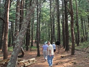
The walk began at 9am on Thursday, August 22; everyone gathered in the small parking area off Namequoit Road. Leading the walk was Kris Ramsay, the OCT Administrator, who began with a little history of the properties: the 46 acre area makes up a portion of the original Kenrick/Sparrow homestead.The land was acquired over 5 years (2002-2007) through 4 separate purchases. Unlike many regions in Orleans (particularly East Orleans) this land was not clear-cut for farming, but instead was planted with trees to be used for timber.
Kris reached farther back into history when discussing the Native Americans in the area. Many of the roads in this area are named after notable Native Americans (Namequoit, Quanset, Portanimicut, etc). Many of these individuals and their families were pushed into South Orleans by the expanding settlements of the colonists. This region near Pleasant Bay was one of the last areas where they had a significant presence in the Lower Cape, especially in what is now Orleans.
Beginning our walk, the most noticeable trees are the large White Pines that aren’t typically found in large numbers in the Cape’s woodlands. Kris noted that we often see a mix of pitch pines and oaks in our woodlands, so the prevalence and size of these white pines is unusual especially because many of them are extraordinarily tall, and outcompeting the oaks for sunlight. Many of these White Pines were planted here long before the oaks and other hardwoods began to establish themselves.
 As we walked along the trail, Kris pointed out a few native shrubs: Huckleberry and High/Lowbush Blueberry; he also pointed out some native groundcovers and other low-growing plants: Sarsaparilla, Virginia Creeper, Striped Wintergreen, Indian Pipe, and Canada Mayflower.
We eventually made our way to the far reaches of the trail, where there were two sites of notable importance. The first of these was the certified vernal pool that is located near the southwestern corner of the conservation area, close to Route 28. Kris noted that the vernal pool is bordered by a large lip of land, with a steep drop down to the vernal pool. This could indicate that this area was once dug out to become a cranberry bog. On the Route 28 side, the land was built up for the road, which further enclosed this former bog. A lack of maintenance meant that it became overgrown with plants while also becoming a critical habitat for many species of amphibians and insects.
The other attraction at the far end of the trail is the presence of a small stand of American Chestnuts. Kris provided the group with a little history on this now-rare tree. This American Chestnut was once found from Maine to Georgia and west to the Mississippi, and was used extensively by colonists for its rot-resistant wood for building, fencing, etc. In 1904, however, a disease called Chestnut Blight was found in some trees, and by 1955 almost the entire population was killed off by this disease, which is still a problem today in the surviving specimens. The blight has been found to be carried by birds as it sticks to their feet when they land on an infected tree. The current method of combating the blight is a recent attempt at hybridizing the American Chestnut with the Horse Chestnut, because the latter is immune to the blight. Biological strategies are being implemented because prevention of the movement of blight via physical means has not been effective.
The significance of this small stand of American Chestnuts comes from the fact that their population is dwindling significantly. There are roughly 100 specimens located on the Kenrick Woods property, but only 5 of these are of reproductive age, meaning they can flower and spread their seeds. The one tree of reproductive age that we encountered on the property is showing signs of being affected by Chestnut Blight. These circumstances are similar to those seen across the state and the country, and illustrate why significant efforts are underway to protect these trees and end or out-with the chestnut blight.
Because these trees are of special concern, if you believe there is an American Chestnut on your property, please contact Kris at 508-255-0183 to coordinate a site visit.
If you missed this walk and would like to see the Kenrick Woods Conservation Area for yourself, it is an easy parking area to get to, located at 35 Namequoit Road, off Route 28. The trails are well-established, and a trail map that can be found and downloaded on the “trails” section of the OCT website.
Join us for our next walk on Tuesday, September 3rd, from 10:00-11:30 am at the Kent’s Point Conservation Area. The parking area is located at 39 Keziah’s Lane, Orleans.
Directions: From Orleans Center, head east on Main Street towards Nauset Beach and turn right on Monument Road. Turn left after about half a mile onto Frost Fish Lane. Follow signs to Kent’s Point.


