New Trail Videos! Explore OCT trails from home.
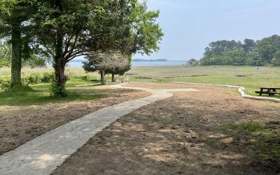
Perhaps you’re new to Orleans, visiting, or just curious about our trails. OCT now offers short 3-5 minute videos of our most popular trails, Mill Pond Valley, Twinings Pond, and Ice House & Reuben's Ponds, showcasing trail highlights, history, accessibility, and family-friendly features. Enjoy beautiful aerial and close-up views, whether you’re planning a walk or exploring from home. Even if you know a trail, you might discover something new!
We welcome your feedback as we create more trail videos. Email us at oct@orleansconservationtrust.org to share your thoughts.
Produced by local videographer and licensed drone operator, Charlie Johnsmeyer. OCT collaborated with Johnsmeyer Films to film the trails in the early spring and summer of 2025.
The walkable open spaces of Orleans are owned and managed by Orleans Conservation Trust or the Town of Orleans. Click the Locator Map to view a map of the town showing each conservation area and its jurisdiction. The map also shows other walkable areas such as public beaches.
Learn about Orleans Conservation Trust trails below.


Each trail offers a unique experience: whether it’s walking through woodlands once used by the Monomoyick Tribe, along pristine shorelines with breathtaking views, or on pathways encircling freshwater ponds, with homes just out of sight. The Trust leads guided walks on these trails and works to help educate the public about both OCT and non-OCT lands.
Whether heading out on your own or joining one of our walks, be sure to observe the generally accepted rules for walking in public places. Please review our policy for bringing dogs on OCT land and the Town of Orleans regulations. Trail markers on trees will guide you on most OCT trails, and it’s always a good idea to carry a trail map—you’ll find printable maps on the page for each area.
The Town of Orleans Conservation Commission manages additional trails in town, including:
- Christian Property
- Baker's Pond
- John Kenrick Woods
- Kent's Point
- Paw Wah
- Peck Property
- Putnam Farm
“When I was still new to Orleans and a part-time resident, I was thrilled to discover the wonderful trails OCT maintains on its properties. OCT introduced me to areas I would not have otherwise seen through wonderful guided walks in places like Woods Cove, Reuben’s Pond, and Twining’s Pond. We’re lucky that these beautiful places are being preserved forever.”
—OCT member Jamie Demas